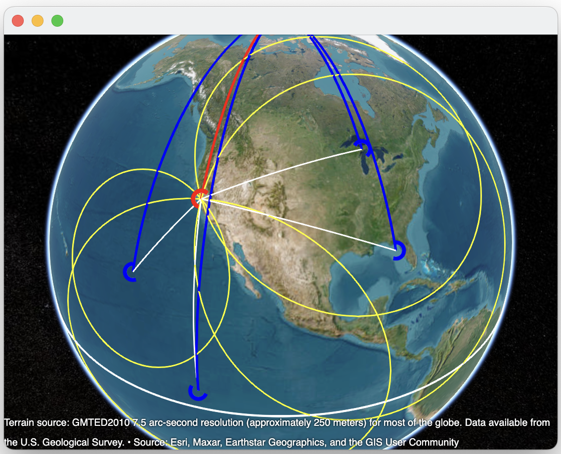
High-accuracy absolute (lat,lon) positions for GPS-denied operations
Astrofix automatically and continously computes your (lat,lon) position by measuring the stars overhead.
| Feature | Benefit |
|---|---|
| Astrofix computes a (lat,lon) position at 5Hz | GPS-like high rates enables advanced digital filtering and accurate positions |
| Wide-angle multipixel images | Simultaneously photograph dozens to hundreds of stars |
| Astrofix automatically identifies the stars | Identified stars enables the Nautical Almanac to be created |
| Astrofix uses the Hipparcos star catalog with over 100,000 stars | Can always generate a solution in contrast to using the USNO 57 star catalog used by mariners where you often will not have 3 or more stars visible at any given moment |
| Astrofix calculates subpixel centroids of bright objects on the photo | Subpixel centroids enables a high angular resolution without using a telescope with limited FOV |
| IMU determines local vertical | Enables the Zenith to be computed |
| IMU senses just the gravity field | IMU is insensitive to linear accelerations |
| Astrofix computes a custom Nautical Almanac using the super accurate Hipparcos star catalog | The celestial coordinates of the stars are precisely known for accurate calculations |
| Astrofix computes a (lat,lon) solution using over-determined least squares | A robust and accurate solution and covariance matrix indicating precision of results |
| Kalman Filtered estimates positions given noisy measurements | An Optimal Linear Estimator results in high accuracy results with low noise |
| Works at any latitude or longitude | Accurate over land, water, including feature-less terrain |
| Low SWaP-C | Easy to configure for UAV, USV, man-portable and mounted applications |
| Works with many camaras including smartphones, Raspberry Pi Camera v3, and Pro-grade telescope finders | Our lightest solution is 22 grams using the RPi Camera v3. Our fastest camera is a ZWO Asi enabling 50 millisecond exposures to minimize motion blur. |
| Automatic calibration and alignment | Every measurement is as accurate as can be |
| Web-based User Interface | Configure Astrofix or review logs using a browser on a smartphone, tablet or computer. |
| Optional SWIR camera | Enables daytime operation. The stars are still there, you just need to look for them in another optical band. |
| No external infrastructure | You just need a view of the sky. |
| Mimics GPS NMEA messages | Can complement or replace GPS in denied, jammed or spoofed areas |
The IMU is rigidly attached and aligned with the camera. This allows the local vertical to be measured and the Zenith to be calculated.
The IMU orientation is ENU with East (X), North (Y), Up (Z). The IMU reports the quaternion [1,0,0,0] when it is flat and aligned with Magnetic North.
The Astrofix web-based UI allows users to configure settings, inspect intermediate calculations, and review logs.
Here Astrofix UI is showing an astrophoto annotated with:
The raw Celestial Navigation (lat,lon) positions are computed using angular measurements between the stars and Zenith, where the Zenith is computed from an IMU. Unfortunately accelerometers in IMUs are inherently noisy, and this results in noise in the Zenith and therefore noise in the computed position.
A Kalman Filter is perfect whenever you have a good mathematical model but noisy measurements. With more samples a KF can estimate the position with substantially lower noise than measured. Here we show how the estimated position rapidly approaches the reference GPS position to quickly achieve CEP below 10 meters.
The figure shows the position from 1000 photos. Astrofix runs at 5Hz so the figure shows how Astrofix converges from power-on to converged solution in 200 seconds. Subsequent KF positon updates are low noise.
Identify stars, Measure star angles, Calculate Circle of Position, Calculate intersection of COPs
CelNav calculates your (latitude,longitude) position by measuring multiple celestial bodies such as stars. Using a sextant an Observer measures the angular height H between the horizon and a star for example Vega. The vector from the center of the Earth to Vega intersects the surface of the earth at a Geographic Point (GP). The location of GP can be computed or looked up for a particular time & date. Draw a circle centered on the GP with a radius coH=90-H. This is the Circle of Position (COP). The Observer can be anywhere on the COP and measure the same height H. So now the Observer knows he is somewhere on the COP!
The Observer now measures the height of a second star for example Sirius. This forms a second COP centered around the GP of Sirius. The Observer position must simultaneously be somewhere on both COP, which only occurs on the intersections.
The Observer now measures the height of a third star for example Hamal. This forms a third COP centered around the GP of Hamal. The Observer position must simultaneously be somewhere on all COP. With three or more sextant measurements the Observer position is uniquely identified. The (lat,lon) position of the COP intersections can be solved for geometrically or algebraically.
Sextant, pencil, tables, & charts. This is the method that Captain James Cook used when circumnavigating the globe in 1768. The first "Nautical Almanac & Epheremides" was published in 1767 by Astronomer Royal Nevil Maskelyne with explanations of how to measure the Moon to compute longitude (without a marine chronometer). This exact same method is taught today to long-distance mariners.
Unfortunately there are very few automatic celestial navigation systems. Why? In 1979 the first GPS satellite was launched, and interest quickly switched to compact GPS/GNSS black boxes that automatically presented very accurate (lat,lon) positions. Even the US Navy stopped teaching CelNav for a decade.
Today CelNav has again become compelling because GPS/GNSS as sole-source PNT has become vulnerable. Complementary navigation systems are critical because they provide essential, secure, and resilient backups to GPS/GNSS, which are increasingly vulnerable to jamming, spoofing, and space-based attacks.
Modern CelNav uses advanced sensors, computers and GPS-like algorithms to enable automated positioning.
The GP move westward as the Earth turns 360 degrees in a sidereal day. Since the GP distance to the Observer is changing, the angular height of the stars is also changing. As a result the COP radii are changing with time. Now you can appreciate that you need accurate time to calculate the COP!
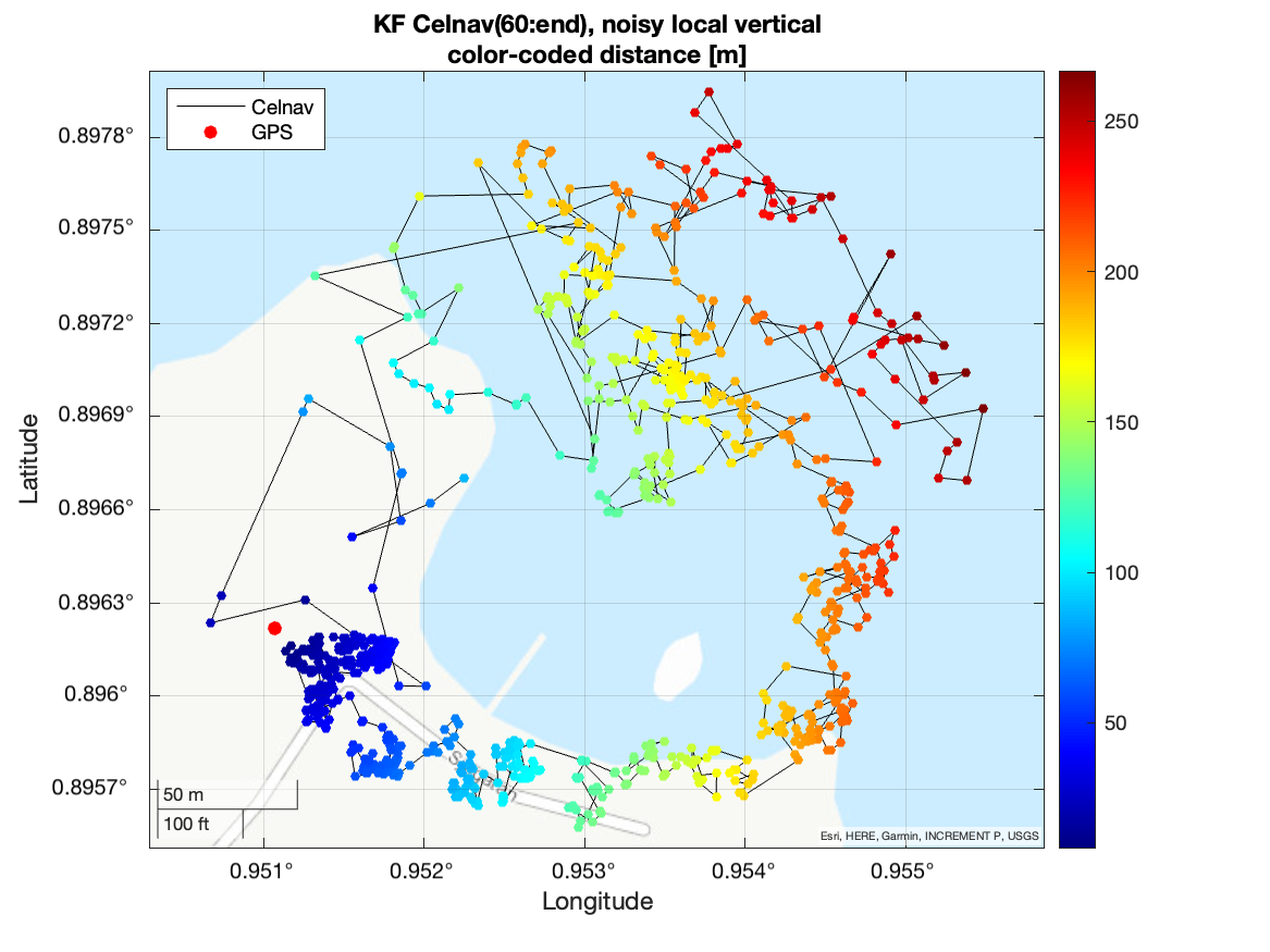
CelNav simulation from a Near Earth view with (49) bright stars of mag<2. For demonstration purposes only the brightest stars in the sky are depicted. The star rays create Geographic Points (GP) on the Earth. Each GP has a Circle of Position (COP) where the radius is the angle to Zenith. As the Earth turns the GP move westward, resulting in continously changing COP radii. Your position is the intersection of the COP.
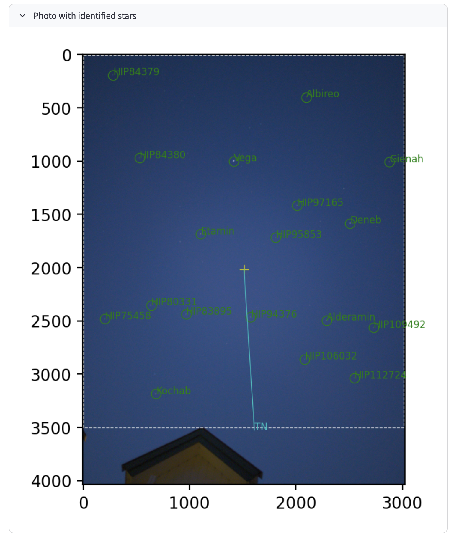
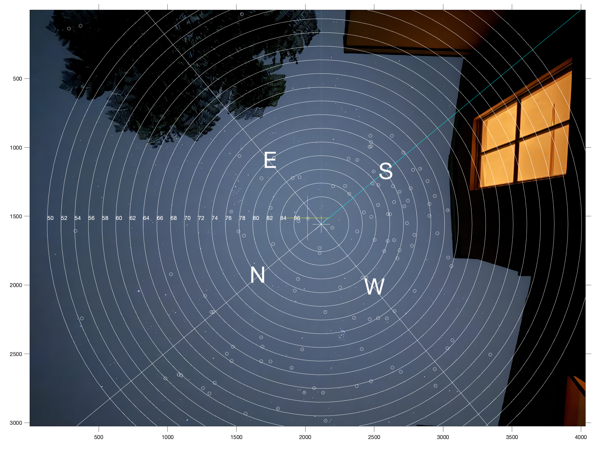
The red rays are from the 57 USNO navigation stars, while the other 118,000 stars in the Hipparcos star catalog are cyan colored. With short 50msec exposures stars of mag<4 are easily detected. There are about 5000 such stars. At least 3 stars are needed to determine your position, but Astrofix will use all to provide a more accurate position.
CelNav simulation from a geosynchronous view with (49) bright stars of mag<2. This view makes it easier to see how the COP evolve with time.
The CelNav objective is to calculate the position of the COP intersections since that is the (lat,lon) of the observer.
Note how the star rays are not homogenously distributed, in particular near the poles. This simulator is useful to plan for how many bright stars are available at any given area and time, suggesting how long the exposures should be.
That said, there are vendors who have sold automatic celestial navigation systems for $3M each. If you want one of those call us and we will refer you :)
Copyright 2026 StarNav Tech
Contact info at starnav dot tech